3. Santa Elena Canyon: Lajitas to Santa Elena Canyon River Access (20 miles)
Gauge Conditions
Runnable: 150.0 – 10,000.0 CFS
Too low for reasonable whitewater trip.
Data from American Whitewater & USGS
Run Map
Run Time Estimate
Select put-in and take-out to estimate time.
Plan This Trip
See wind-adjusted speed maps, forecast planning, and detailed time estimates.
Sign in to generate an AI timing estimate for this run.
Whitewater timing varies with scouting, portages, and group pace. Use as a planning baseline.
Description
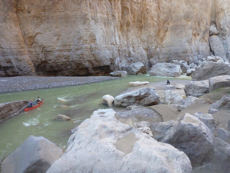
In whitewater terms, the Rio Grande is not particularly challenging, but paddling through Santa Elena Canyon should still be on every whitewater paddler's bucket list, simply because of the scenery. Santa Elena Canyon is a relatively narrow gorge (100-150 feet wide) with sheer cliff walls that tower as much as 1/4 mile above the river on both sides. Unlike most canyons, Santa Elena also has two mouths-- the upper end looks just like the lower end. This is one of the most remote and untamed stretches of river in Texas. At Entrance Camp, you are at one of the least accessible points in Big Bend National Park, a place experienced only by a few paddlers every year-- and by the horses that run wild along the banks of the river.
At low to moderate levels, there are several "wall shot" rapids inside the canyon that are arguably more difficult than the named rapids (Matadero, etc.) above the canyon. Generally, all of these rapids-- in addition to the named Class II rapids-- will require some maneuvering by canoeists, particularly when the river is relatively low and channelized. However, whitewater paddlers will probably find them to be straightforward. This section gets pushy at high levels (thousands of cfs), but most of the rapids (with the exception of Rock Slide) wash out at those levels.
This stretch is doable as a day trip when the river is running high (> 1000 cfs.) It can be rafted down to 500 cfs as a 2-day trip and canoed or kayaked as a 2-day trip down to 150 cfs. The entire section of river is in Big Bend National Park and requires a permit obtainable at park headquarters or in Lajitas. The state and national parks require anyone on a river trip to wear their PFD's through named rapids. All of the river access points are on river left (Texas side.)
Distances and gradient measured using GIS tools in 2015.
Difficulty
Class II(III)
Length
20.6 mi
Gradient
7 ft/mi
Rapids
9
Access Points
Difficulty Classes
I Easy
II Novice
III Intermediate
IV Advanced
V Expert/Extreme
VI Unrunnable
Current Conditions
5-Day Forecast
Whitewater data from
American Whitewater
American Whitewater