C) Estabrook Park to N.Riverboat Road (PnP or up to 3.6 miles)
Gauge Conditions
Runnable: 120.0 – 9,999.0 CFS
Intermediate flow. Perhaps ideal flows for beginner-to-intermediate boaters (full run or PnP at EPL, UPk, TD or North Ave). (See description for details.)
Data from American Whitewater & USGS
Run Map
Run Time Estimate
Select put-in and take-out to estimate time.
Plan This Trip
See wind-adjusted speed maps, forecast planning, and detailed time estimates.
Sign in to generate an AI timing estimate for this run.
Whitewater timing varies with scouting, portages, and group pace. Use as a planning baseline.
Description
Quick Facts:
Location: Glendale/Milwaukee (starting about 4.5 miles north of downtown Milwaukee, ending 2 miles northeast of downtown).
Put-in parking: 43.1011, -87.9077 (Estabrook Park, Milwaukee)
Take-out: *43.0584, -87.8953* (N.Riverboat Road, Milwaukee)
Shuttle Length/DriveTIme: 3.6 miles/~10 minutes *Shuttle Route*
Put-in elevation is approximately 610'
Take-out elevation is approximately 580'
Total drop is approximately 30'
10/85 Gradient Upstream of Put-in: 4.8 fpm
Percent Developed Upstream of Put-in: 17.3 %
(The higher the above two values, the 'flashier' the stream will be.)
Drainage area at put-in: 688 square miles
Drainage area at take-out: 694 square miles
Drainage increase: 0.9%
Rivers with Similar Drainage Area: Baraboo (609 sq.mi.), S.Fk.Flambeau (609 sq.mi.), Eau Claire (Little Falls to Big Falls, 760 sq.mi.), Fox (Rochester Dam, 767 sq.mi.)
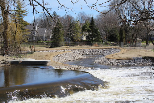
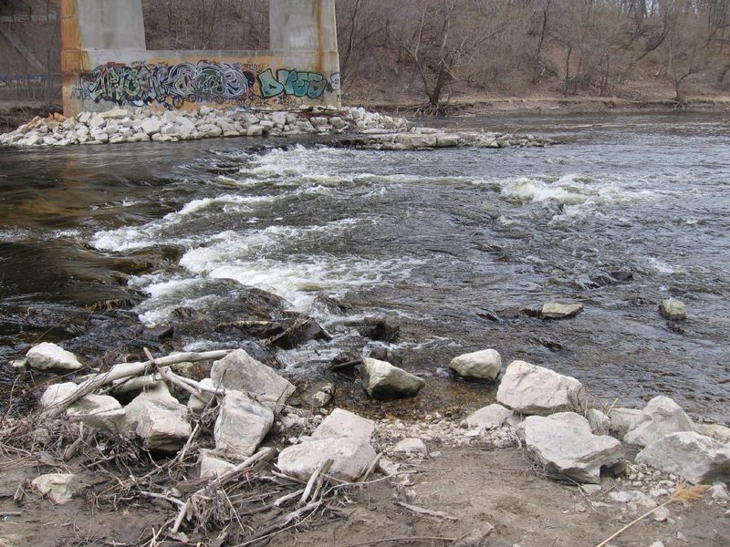
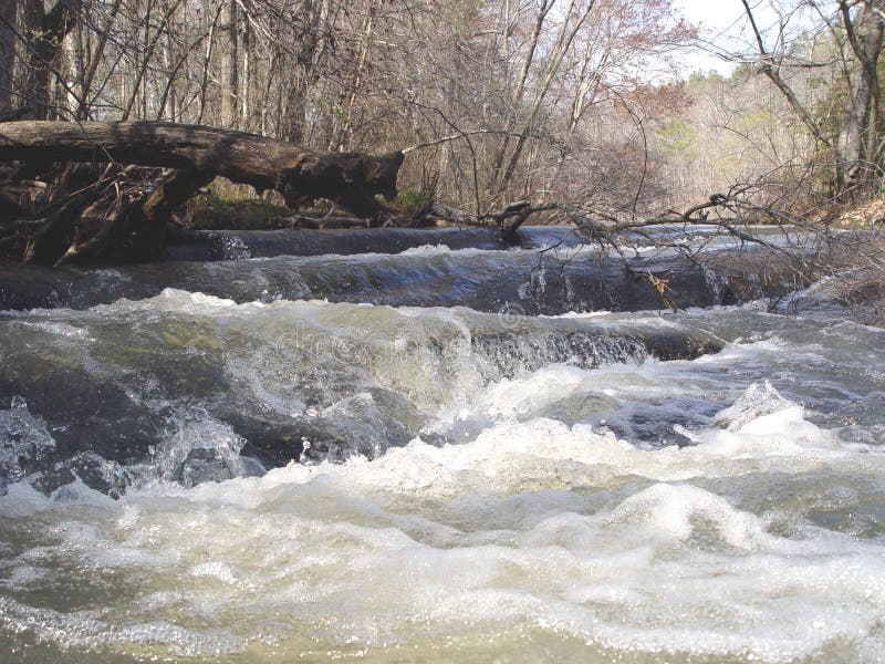
Character: A relatively deep, tree-surrounded river-corridor creates a green oasis in the city. Rocky shoals, bedrock ledges, an old timber dam, and paver-block remediation create areas of riffles, rips, and minor rapids on an otherwise flatwater river. Very pool/drop (distinct/discrete drops followed by wide slow pools). Generally wide-channel with multiple routes.
River banks: Generally reasonable egress, with rocky or grassy banks. Immediate floodplain varies (narrow to wide).
Typical width: 50-180 ft.
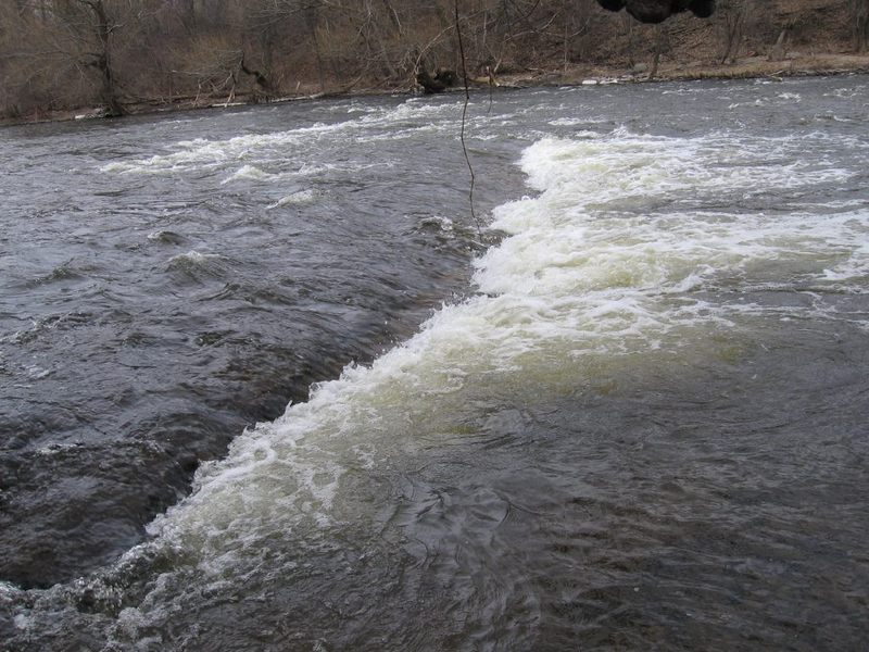
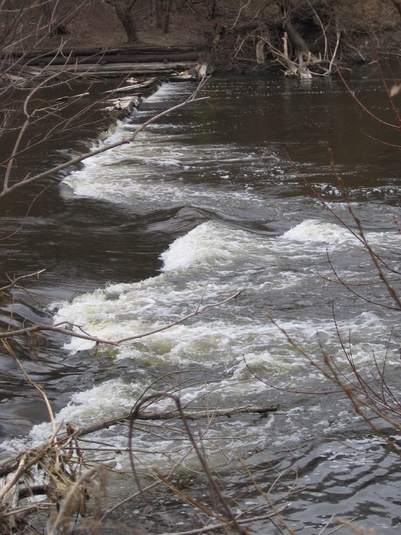
Longest rapids: Rapids stay generally short through most normal/usual recommended flows. At flows above 1000-2000 cfs, the North Avenue stretch will be ~1000' (nearly 0.2 mile) of pretty continuous 'push', and the U-Park shoals will be up to 2000' (nearly 0.4 mile) of continuous splishy-splash leading to the U-Park Ledge Waves.
====================================================================
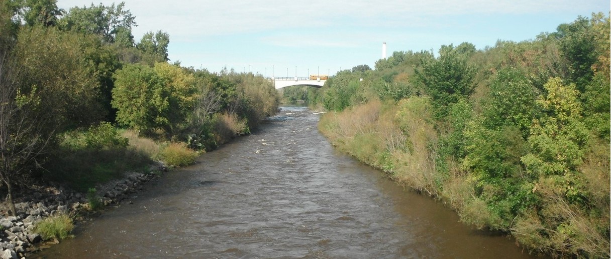
While there will be reminders that you are in the city (radio towers, three well-overhead bridges you'll pass under, occasional houses, highrises, and factories visible from the river), the river sits in a relatively deep, tree-lined valley, making it a pleasant escape from (and almost possible to forget) the bustle of the city surrounding the river. Indeed, much of the run has an almost 'up North', 'wilderness' feel to it! Since the river is one of the larger watersheds in the area (at 696 square miles), it will generally retain adequate flow after other rivers in the area are too low to boat.
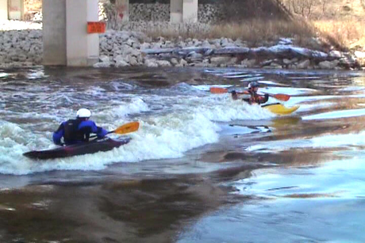
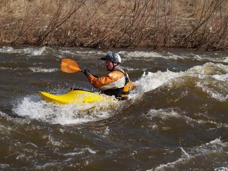
Whitewater play-boaters often eliminate the need for a shuttle and just 'park-and-play' at some of the main sites which can offer tame play even down to fairly low summer flows. Similarly, they may opt to paddle a short-shuttle or upstream paddle and portage section. (All features occur where they can be accessed from convenient parking.)
Both the Timber Dam / Locust Street location and North Avenue location allow boating after sunset, by street lights on the bridges as well as the general glow of the city. Disclaimer: both locations are in what may be somewhat questionable neighborhoods (though with UW-Milwaukee dorms now flanking the river at North Avenue, and condos lining N.Riverboat Road, this area is much improved). I have boated both locations a good number of times after sunset with no problems or concerns arising (though I won't guarantee that to always be the case).
The North Avenue location will sometimes allow winter paddling, as it can remain (or flush) free of ice. Extreme caution is urged for those who opt to boat this in winter months. Rip-rap rocks on shore will often be icy, and the river just downstream of this stretch will be frozen over. Mis-steps and miscalculations (or swims) will be punished (perhaps with your life if you flush under the ice). Make certain you check the ability to get out (especially if there are ice-shelves from shore) before putting in! It is strongly recommended (for winter paddling, when ice is present on shore) to get out at the pool either above or immediately below the rubble rips, as exit from the river downstream (nearer the pedestrian bridge spanning the flanks of the former dam) is generally much more difficult and potentially treacherous!
====================================================================
Cyclists have many options for biking a shuttle. The most direct will be to cross over the pedestrian bridge (sitting across the flanks of the old dam), to head upstream on the 'East Bank Trail', and from which you can move up to the Oak Leaf Trail (via a switchback just north of Locust Street). On the west side of the river, the Beerline Trail will take you to Locust at Humboldt before it angles west (away from the river). At that point, you have two options. 1) Take Locust east to cross the river, then head north on Cambridge Avenue, then look for a path/break in the trees which separate the street from the Oak Leaf Trail. 2) Use bike lanes to continue on north on Humboldt to Capitol, cross the bridge then continue up either the Oak Leaf Trail or the parkway road to get to Estabrook Beer Garden and our recommended put-in.
Alternatively, if you're an avid off-road cyclist, bring your off-road bike along and rid challenging (unofficial) single-track trails either side of the river from North Avenue to Capitol Drive (complete with a few 'stunts', if that's your thing). My subjective evaluation (with a disclaimer that I'm, at best, a novice off-road biker):
river-right (west bank) (north or south): novice, \*\* NOTE: parts of this trail are on private property, so technically you are trespassing
river-left (east bank) north (upriver): high-intermediate,
river-left (east bank) south (downriver): expert.
NOTE: these are not 'approved' trails, but are maintained by an avid group of local off-road bikers.
Additional References
Milwaukee Riverkeeper provides a fine map which covers this section of river.
Rapids in this Run (9)
Rapid
Lincoln Park (Island Put-in)
Rapid
*** WATER QUALITY ISSUES: CSO ***
Rapid
*** WATER QUALITY ISSUE: PCB ***
Rapid
FORMER SITE of Estabrook Dam
Rapid
Estabrook Beer Garden Parking ** Recommended Put-in **
Rapid
I
Capitol Drive shoals
Rapid
North Avenue Park-and-Play
Rapid
Homeless (Wave)
Rapid
II+
Space Bar ("SB")
Waterfalls (2)
Playspots (9)
Hazards & Portages (4)
Caution: The following locations may require scouting or portaging. Always check current conditions.
Difficulty
Class I-II(III)
Length
3.5 mi
Gradient
10 ft/mi
Rapids
9
3 Hazards
1 Portage
Access Points
Shuttle Info
Whitewater playboaters may often just do 'park-and-play' at one or more locations needing no shuttle, or shuttling between two or more spots.
With removal of the Estabrook Park dam, the road and parking lot at that location have been permanently closed.
The recommended put-in is from the Beer Garden and ballfield parking lot in Estabrook Park, in the NORTHWEST end of the lot (away from the ballfield and Beer Garden). Carry (either on a paved path or across grass) to a flight of uneven stonework stairs down to the river.
For directions to the put-in (via your mapping/routing app) use the address Estabrook Beer Garden, Milwaukee.
At the take-out, serious whitewater (play) boaters are likely to exit the river before the flanks of the old dam (now straddled by a pedestrian/bicycle bridge), using street-parking spots furthest toward the end of the road (across from the last building on the street).
For directions to the take-out (via your mapping/routing app) use the address 2280 N.Riverboat Road, Milwaukee.
Novice paddlers are likely to proceed beyond the flanks of the dam to an improved canoe landing an river-right (readily identified by LARGE quarried rock). In this instance, you'd want to park more near the River Revitalization Foundation building (a ranch-style house with 'green roof'), using its address: 2134 N.Riverboat Road, Milwaukee.
In fact, many novice paddlers are likely to use a take-out point well downstream of the listed area, paddling perhaps to one of the brewpubs which abut the river downstream of here.
To get to the _Timber Dam_ site (from the take-out at Riverboat Road):
1) Head SW on Riverboat Road 0.2 mile
2) Turn right, then right again to double-back on Commerce Street.
3) Turn left (North) on Humboldt Boulevard for 1.1 miles (past North Ave, and two blocks past Locust Street).
4) Turn right (East) on E.Chambers Street 0.1 mile, parking on street, then carry straight down to the river (starting on paved path/road outside the Pumping Station fence).
For directions to Timber Dam (via your mapping/routing app) enter 43.0739 -87.8928 as coordinates, or use the address 1234 E.Chambers Street, Milwaukee.
For directions to the U-Park (via your mapping/routing app) enter
the address 4400 N.Humboldt Boulevard, Milwaukee.
And, again, for directions to the put-in (via your mapping/routing app) use the address Estabrook Beer Garden, Milwaukee.
Difficulty Classes
I Easy
II Novice
III Intermediate
IV Advanced
V Expert/Extreme
VI Unrunnable
Current Conditions
5-Day Forecast
Whitewater data from
American Whitewater
American Whitewater