How's Your
River
×
Explore
Explore Map
Water Bodies
Gauges
Access Sites
Tidal Stations
Whitewater
Pricing
Login
Sign Up
Hazard Warning:
Hazard information may be user-submitted and unverified. Conditions change frequently. Always scout rapids and obstacles yourself.
Whitewater
Georgia
Chestatee - 3 - Copper Mine to Lumpkin County Park
Appalachian Outfitters
Rapid
GA
Appalachian Outfitters
Chestatee - 3 - Copper Mine to Lumpkin County Park (GA)
Monitor this Rapid
Water Body
This Run
Map
Other Rapids
Gauge
Weather
Directions
Gauge Conditions
Chestatee River near Dahlonega, GA
Downstream
Primary
Runnable: 200.0 – 20,000.0 CFS
Data from
American Whitewater
&
USGS
Photo
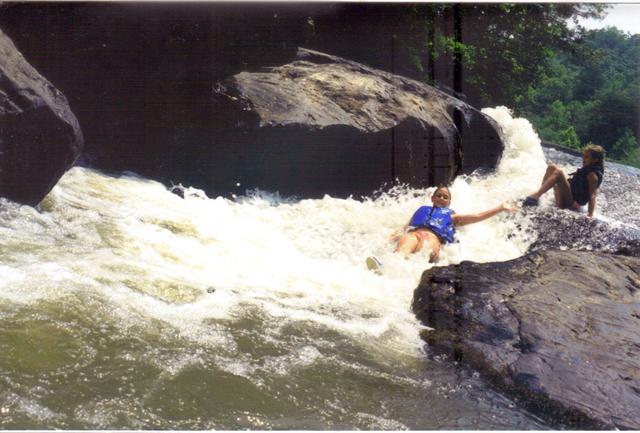
Photo courtesy of
American Whitewater
Description
The outfitter's access is not that easy to see from the river: look for a set of wooden stairs on the river right bank.
Location
Radar
Counties
Cell
Verizon
AT&T
T-Mobile
Dark
Satellite
Terrain
Other Rapids on This Run (6)
Hazard
III+
Copper Mine rapid
0.0 mi
Hazard
II
Blasted Rock
4.1 mi
Rapid
Highway 52
4.7 mi
Hazard
I
Gold Digger Shoals
8.1 mi
Rapid
Highway 400
14.4 mi
Rapid
Lumpkin County Park
18.3 mi
Type
Rapid
Mile Marker
8.5 mi
Directions
Navigate
View Full Run
3 - Copper Mine to Lumpkin County Park
Chestatee
I-II(III)
28.9 mi
Current Conditions
5-Day Forecast
Whitewater data from
American Whitewater
Appalachian Outfitters