How's Your
River
×
Explore
Explore Map
Water Bodies
Gauges
Access Sites
Tidal Stations
Whitewater
Pricing
Login
Sign Up
Hazard Warning:
Hazard information may be user-submitted and unverified. Conditions change frequently. Always scout rapids and obstacles yourself.
Whitewater
Georgia
Chestatee - 3 - Copper Mine to Lumpkin County Park
Highway 52
Rapid
GA
Highway 52
Chestatee - 3 - Copper Mine to Lumpkin County Park (GA)
Monitor this Rapid
Water Body
This Run
Map
Other Rapids
Gauge
Weather
Directions
Gauge Conditions
Chestatee River near Dahlonega, GA
Downstream
Primary
Runnable: 200.0 – 20,000.0 CFS
Data from
American Whitewater
&
USGS
Photo
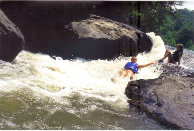
Photo courtesy of
American Whitewater
Description
Alternate put-in/take-out. Best access between the river and the dirt road is on river left about 100 yards before the bridge, just below the gauge building, but is steep enough to be a challenge.
Location
Radar
Counties
Cell
Verizon
AT&T
T-Mobile
Dark
Satellite
Terrain
Other Rapids on This Run (6)
Hazard
III+
Copper Mine rapid
0.0 mi
Hazard
II
Blasted Rock
4.1 mi
Hazard
I
Gold Digger Shoals
8.1 mi
Rapid
Appalachian Outfitters
8.5 mi
Rapid
Highway 400
14.4 mi
Rapid
Lumpkin County Park
18.3 mi
Type
Rapid
Mile Marker
4.7 mi
Directions
Navigate
View Full Run
3 - Copper Mine to Lumpkin County Park
Chestatee
I-II(III)
28.9 mi
Current Conditions
5-Day Forecast
Whitewater data from
American Whitewater
Highway 52